De Glind
Appearance
De Glind | |
|---|---|
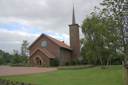
 Church of De Glind | |
Location in the province of Gelderland | |
| Coordinates: 52°7′9″N 5°30′23″E / 52.11917°N 5.50639°E | |
| Country | Netherlands |
| Province | Gelderland |
| Municipality | Barneveld |
| Area | |
| • Total | 6.15 km2 (2.37 sq mi) |
| Elevation | 6 m (20 ft) |
| Population (2021)[1] | |
| • Total | 620 |
| • Density | 100/km2 (260/sq mi) |
| Time zone | UTC+1 (CET) |
| • Summer (DST) | UTC+2 (CEST) |
| Postal code | 3794[1] |
| Dialing code | 0342 |
De Glind is a village near Barneveld in the middle of Netherlands, in the province Gelderland.
History
[edit]It was first mentioned in 1321 as Ghelinde, and means "fenced off terrain".[3] The havezate Glinthorst was mentioned for the first time in 1325. It was demolished around 1780.[4] In 1840, it was home to 498 people. In 1916, a church was built in De Glind.[5]
In 1911, Foundation De Glindhorst was established by Roelof Jan Willem Rudolph and a village for disadvantaged youth was built. Farmers could rent a piece of land, but were obliged to take care of children. The youth village still exists, and is nowadays operated by the Rudolph Foundation.[5]
Gallery
[edit]-
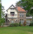
House in De Glind
-
Cows with a farm in the background
-
Remembrance water well
-
Leapfrog detail
References
[edit]- ^ a b c "Kerncijfers wijken en buurten 2021". Central Bureau of Statistics. Retrieved 19 March 2022.
- ^ "Postcodetool for 3794MD". Actueel Hoogtebestand Nederland (in Dutch). Het Waterschapshuis. Retrieved 19 March 2022.
- ^ "De Glind - (geografische naam)". Etymologiebank (in Dutch). Retrieved 19 March 2022.
- ^ "Glinthorst". Klein Moorst (in Dutch). Retrieved 19 March 2022.
- ^ a b "De Glind". Plaatsengids (in Dutch). Retrieved 19 March 2022.
External links
[edit]


