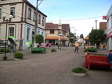
São Bento do Sul

São Bento do Sul is a municipality, pop. 85,421 (2020)[1] located in southern Brazil, in the northeast part of the state of Santa Catarina, just south of the state of Paraná.
Industry
[edit]São Bento do Sul is considered to be an industrialized city.
There are many strong industries active in the region but the municipality is best known for its production of furniture and textiles.
Pioneer days
[edit]São Bento do Sul was first settled by the Kolonisations Verein von 1849, in Hamburg, a 'for profit' colonization enterprise (as opposed to the State of provincial colonization efforts that were also taking place at that time) established in Hamburg, Germany.
Today there are different festivals celebrating the local population's immigrant roots: German, Italian, Polish, Czech, and others.
Climate
[edit]| Climate data for São Bento do Sul, elevation 850 m (2,790 ft), (1976–2005) | |||||||||||||
|---|---|---|---|---|---|---|---|---|---|---|---|---|---|
| Month | Jan | Feb | Mar | Apr | May | Jun | Jul | Aug | Sep | Oct | Nov | Dec | Year |
| Record high °C (°F) | 35.0 (95.0) |
34.0 (93.2) |
33.0 (91.4) |
30.7 (87.3) |
28.0 (82.4) |
26.2 (79.2) |
28.0 (82.4) |
30.0 (86.0) |
32.0 (89.6) |
32.0 (89.6) |
33.8 (92.8) |
33.3 (91.9) |
35.0 (95.0) |
| Mean daily maximum °C (°F) | 26.6 (79.9) |
27.3 (81.1) |
24.8 (76.6) |
22.6 (72.7) |
21.2 (70.2) |
19.8 (67.6) |
20.1 (68.2) |
19.8 (67.6) |
19.6 (67.3) |
22.6 (72.7) |
23.9 (75.0) |
25.1 (77.2) |
22.8 (73.0) |
| Daily mean °C (°F) | 20.2 (68.4) |
20.8 (69.4) |
19.2 (66.6) |
16.4 (61.5) |
13.8 (56.8) |
12.2 (54.0) |
12.8 (55.0) |
12.9 (55.2) |
14.6 (58.3) |
15.7 (60.3) |
17.9 (64.2) |
19.2 (66.6) |
16.3 (61.4) |
| Mean daily minimum °C (°F) | 16.1 (61.0) |
16.6 (61.9) |
15.5 (59.9) |
12.3 (54.1) |
9.3 (48.7) |
9.3 (48.7) |
7.5 (45.5) |
7.8 (46.0) |
8.2 (46.8) |
9.3 (48.7) |
11.6 (52.9) |
15.0 (59.0) |
11.5 (52.8) |
| Record low °C (°F) | 6.3 (43.3) |
9.0 (48.2) |
9.0 (48.2) |
−1.1 (30.0) |
−4.3 (24.3) |
−7.0 (19.4) |
−4.9 (23.2) |
−4.7 (23.5) |
−3.3 (26.1) |
−0.4 (31.3) |
5.0 (41.0) |
5.2 (41.4) |
−7.0 (19.4) |
| Average precipitation mm (inches) | 172.9 (6.81) |
168.5 (6.63) |
123.1 (4.85) |
90.9 (3.58) |
129.0 (5.08) |
115.9 (4.56) |
123.1 (4.85) |
95.1 (3.74) |
131.7 (5.19) |
136.6 (5.38) |
122.8 (4.83) |
145.0 (5.71) |
1,554.6 (61.21) |
| Average relative humidity (%) | 84 | 87 | 88 | 86 | 89 | 88 | 87 | 86 | 85 | 85 | 83 | 85 | 86 |
| Mean monthly sunshine hours | 160 | 135 | 124 | 107 | 125 | 133 | 128 | 130 | 122 | 146 | 139 | 130 | 1,579 |
| Source: Empresa Brasileira de Pesquisa Agropecuária (EMBRAPA)[2] | |||||||||||||
See also
[edit]References
[edit]- ^ IBGE 2020
- ^ "Atlas climático da Região Sul do Brasil: Estados do Paraná, Santa Catarina e Rio Grande do Sul" (PDF). EMBRAPA. Archived from the original (PDF) on 14 January 2024. Retrieved 25 May 2024.
26°15′S 49°23′W / 26.250°S 49.383°W
